Tohoku in 708
In 708 (Wadou 1) the Japanese government established Ideha district north of Echigo. But in the following year, according to Shoku Nihongi, ''the Emishi of the two countries (kuni) of Michinoku and Echigo had ambitions and were difficult to tame, often harming good people''. We can assume from this that the Emishi hated the settlement of Japanese in their territories and began a rebellion to keep them out.
In response, the Japanese government gathered soldiers from the countries (kuni) of Totomi, Suruga, Kai, Shinano, Kozuke, Echizen and Etchu. On March 5, Kose no Maro was appointed as the Pacifying East General of Michinoku (Michinoku Chin'to Shogun) for the northeast front. Saeki no Iwayu was appointed as the Conquering General of Echigo and Emishi (Sei Echigo Emishi Shogun) for the northwest front. The Government ''made other countries transport arms to Ideha fort for the purpose of conquering the Emishi'', and ''ordered [that] the four countries of Echizen, Etchu, Echigo and Sado send 100 ships to the Place of Conquering North-Barbarian (Seitekijo)'' in July. This place may have been Ideha fort the central seat of the western front, however this is unclear.
On 25 August general Saeki returned from the campaign and was praised by the government for successfully consolidating the western front. There was no record about the outcome of Kose's mission.
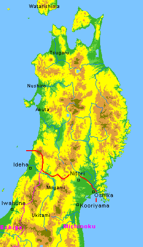
Putting the record aside let's examine the map. The Japanese had two fronts for accessing the northern frontier: Michinoku and Echigo. On the Japan Sea coast side mountains hampered the land route between Iwafune and Ideha. Even though it was not impossible to cross, it was very difficult to transport supplies or large armies by land. Ships moving along the Japan Sea coast had much better access, and they were used to transport military supplies and troops to this area. On the eastern side, access to the large Sendai plain was easier. The Japanese could use both the broad valley of the Abukuma river and the coastal plain along the Pacific Ocean for access.
Archeologists have found ruins of Japanese official fort towns from the late 7th century on the Sendai plain. One of these is the Kooriyama ruin (probably the Michinoku country capital), Fort Oshika and Fort Nitori on this map.
Creating the settlement in Ideha was an isolated adventure. It was not part of the mutual support network of forts such as that developed in Michinoku, but was heavily dependent on ship transport. Later this same scenario was repeated in the building of Akita Castle.
In 712, the government decided to promote Ideha from a district to a country (kuni). Soon thereafter, Okitama district and Mogami district were detached from Michinoku country and incorporated into Ideha country. With the establishment of Ideha the northwestern frontier was opened for further Japanese settlement.